I like Google Maps, but I’ve found there are a few minor problems when you ask it to calculate the best driving route between two points. Usually, they’re peculiar little errors, such as this one: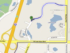
Why does Google Maps send me all the way around Lake Emma, when I could just turn left onto Primera Blvd.? Primera isn't a one-way street. It’s a bug, but it got me thinking about circuitous routes.
I started to wonder if I could find other painful driving routes using Google Maps. They wouldn’t have to be errors, just unavoidable. For example, the distance from Terrace Bay, Ontario to Calumet, Michigan is only 230 miles as the crow flies. But to drive from one to the other sends you all the way around Lake Superior, for a total distance of 576 miles. In other words, it’s 250% farther away by road.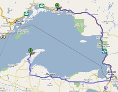
Pagosa Springs, Colorado is only about 32 miles from Jasper, Colorado as the crow flies. But thanks to the formidable Rocky Mountains, the driving distance is 95.4 miles – a 298% difference.
And Grand Canyon City, Arizona is a little more than 66 miles from Fredonia, Arizona, but if you have to make the drive around the Grand Canyon, it’s 200 miles – a 300% difference.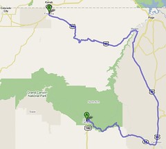
I tried some other, obvious physical boundaries, like the Sea of Cortez in Mexico, the Red Sea and the Persian Gulf, but Google Maps is unable to calculate driving directions for the countries involved. Some cities on opposite sides of large bodies of water have already become fed up with the long drive, and have created ferry routes or bridges, and Google Maps happily takes advantage of these conveniences.
So the question is, can you beat my best score of 300%? Remember, it’s not the total distance, it’s the difference between the straight-line distance and the actual driving distance.
Thursday, September 11, 2008
The Long Way Around
Subscribe to:
Post Comments (Atom)

6 comments:
I don't have the patience to beat it, but I do remember a funny thing they used to have. If you wanted to get to London from, say New Jersey, one of the steps would be for you to swim thousands of miles across the Atlantic. This is not a bug because the scripting clearly tells you to swim 3,000+ miles. Here is a link to a guy who documented it -- it no longer exists on the current google maps application. http://www.informationmadness.com/cms/index.php?option=com_content&task=view&id=95&Itemid=9
Tim,
I think your 300% limit, may be more related to scale than the actual circuitous routes. Vergennes,VT and Westport, NY are on opposite sides of a very narrow section of Lake Champlain. It's only about a mile across the water, maybe 1.25 to actual roads you can drive on, but the google route is 36.2 miles around the southern end of the lake, or at least to a point where it's narrow enough to put a bridge across. That calculates to around 3000% (unless one of us screwed up the math). If I go a little bit north, it routes me across using the ferry but I don't know if it counts the distance you ride on the boat, still 20x further. There are a number of places along the Hudson River that fall into the same category, in Downeast Maine I'm sure I can find a bunch, and I bet around Chesapeake Bay too. My real difficulty is with the greater than 100% approach; 3X as far is 300%, so accordingly 30X is 3000%. It may be mathematically correct but it seems funky. But maybe I missed the point.
Casual_Observer2 aka CO2
RDL
I guess I was trying to get people interested in trying to find similar routing problems. I just did it casually a few times to prime the pump, and the best I came up with at that time was 300%. However, I'm absolutely certain that figure can be beaten. Remember, it's not the distance, it's the percentage difference between the "crow flies" distance and the "driving" distance.
I went looking again, and beat my own score. First, the direct distance between Painesville, Ohio and St. Thomas, Ontario is a mere 3 1/8 miles across Lake Erie. But thanks to no ferry service, it's a 313 mile drive - a difference of 375%. But if you really want a painful drive, try Interlaken, NY to Atwater, NY. The distance across Cayuga lake is only 1 3/8 miles, but you have to drive 36 miles around the lake for a whopping difference of 818%!
I know that figure can be beaten, so if you have some time on your hands, see what you can do. I haven't even tried rivers, which are much narrower than lakes, so should yield larger percentages - unless they have bridges, which they do.
Remember, you can't get theya from here...
Today's maps are generally better but when they 1st came out I'd find weird problems. I typed in my home address and up came a map with my street surround by streets I didn't recognize. I backed out a little and saw I was in Waltham 20 miles from my address. I went back and checked my search and sure enough I had my town and zip code listed. I tried different neighbors addresses and they were fine. For some reason just our address got teleported to a totally new place. It would be real interesting for someone to try to find us who didn't know this quirk.
the "while we're out" map or "It's on the way" map...
distance from my house to the local store = 2.0 miles
Distance from my house to the local store (including the "While we're out" stops = 544 miles...
I hate to think what that calculates to.... does this happen to anyone else?????
Post a Comment